
Dashboard / River / River Wye at Symonds Yat
River Wye at Symonds Yat
A wide, slow, meandering reach below a limestone gorge, with a shingle beach and a ferry that has run on a rope since the 18th century.
Monthly water temperature temperature
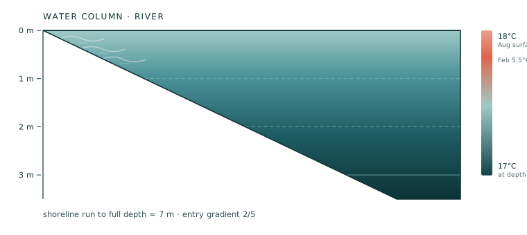
The surface runs about 18 °C in August. The annual low is 5.5 °C in January and the high is 18 °C in July. No pronounced summer thermocline is recorded here. For October, the mean surface figure is 12.5 °C.
| Jan | Feb | Mar | Apr | May | Jun | Jul | Aug | Sep | Oct | Nov | Dec |
|---|---|---|---|---|---|---|---|---|---|---|---|
| 5.5 | 5.5 | 7 | 9.5 | 13 | 16 | 18 | 18 | 16 | 12.5 | 9 | 6.5 |
Safety safety
The Wye is a Site of Special Scientific Interest and is monitored by Natural Resources Wales for both ecology and bathing suitability. The main concern in dry summers is phosphate-driven algal growth rather than bacteria.
Safety notes (3)
- The hand ferry runs on a steel cable that sits below the surface at high water. Never swim across the ferry line.
- Canoe traffic is heavy here. In July and August, hundreds of hire canoes pass per day, and most are steered by beginners. Swim close to the bank.
- The Wye rises quickly after rain in the Welsh hills — up to a metre overnight. Camp well above the bank and check the gauge at Ross-on-Wye before a long swim.
Where to get in
- Shingle beach — Below the ferry landing on the east bank; 40 m of shingle at 1:10, wadeable to the chest.
- Hand ferry steps — Concrete steps to 2 m of water. Convenient but exactly on the ferry line — check where the cable is before using them.
On site
- Two pubs with riverside gardens (the Saracen's Head and the Royal Lodge)
- Canoe hire and a campsite 400 m upstream
- Public toilets at the car park
Getting there arrival · entry · exit
Getting there
From the Symonds Yat East car park, walk down the lane past the ferry landing. The shingle beach starts where the lane ends, three minutes from the car.
The view from Symonds Yat Rock, 20 minutes' climb on the west side, is worth doing before you swim — it shows you exactly where the deep pool sits on the outside of the bend.
Getting in
Wade in from the shingle. You will be at knee depth for the first 15 m, which makes this the easiest river entry here for nervous swimmers and children.
Swim upstream along the inside of the bend to the gravel run, then turn and drift back. Because the flow is only around 0.25 m/s, a 400 m round trip is comfortable and takes about 15 minutes.
Getting out
Exit on the shingle — it is firm, and the ferry landing has a slipway you can use if the beach is busy.
The riverside pub gardens are the standard post-swim stop, but they are 3 minutes uphill and the lane is steep; carry dry clothes up rather than changing on the beach in front of the ferry queue.
Depth profile
A long shallow run over gravel that only reaches 1 m at 15 m out, followed by a 3.5 m pool on the outside of the bend where the ferry cable crosses. The inside of the bend is a shingle beach with a 1:10 gradient — the most gradual river entry on this list.
Season window
June to mid-September; the Wye is a spate river and clears 24–36 hours after rain
Cold-water questions
- Is the Wye safe for children?
- The east-bank shingle beach is the most suitable spot on this list for children, with 15 m of knee-deep water and a 1:10 gradient — but there is no lifeguard and canoe traffic is real.
- Why is the Wye sometimes brown in summer?
- Fine sediment from agricultural run-off and algal growth driven by phosphate. It usually clears within 24–36 hours of a dry spell.
Before you get in
Cold water is the one hazard that applies everywhere in this library. Below 15 °C the gasp reflex can make you inhale water involuntarily within seconds of immersion; below 10 °C, unacclimatised swimmers lose the ability to swim effectively within minutes. Enter gradually, keep your first session under five minutes, never swim alone, and get out while you still feel fine — the afterdrop continues after you leave the water.
Informational only. Stillwater is not a safety authority, a lifeguard service or a medical source, and nothing here is professional advice. Water conditions change within hours: temperatures are monthly means, not today's reading, and depth profiles are typical rather than surveyed. Before you enter any water, check the current conditions, read the on-site signage, follow the advice of local lifeguards above anything on this page, and if you are unsure of your ability in cold water, do not go in.
Other spots of the same water type
| River Dart at Newbridge | Devon, England | 2.6 m | 12.5° October |
| Upper Rhine at Rheinau | Schaffhausen, Switzerland | 6.5 m | 13° October |
| Berounka at Branov | Central Bohemia, Czechia | 2.2 m | 12° October |
| River Wharfe at Grassington | Yorkshire Dales, England | 3 m | 11.5° October |